Tocht Stappen Le Boulou - Le Boulou, chapelle saint Phillipe, mas d'en Conte - Photo

Le Boulou, chapelle saint Phillipe, mas d'en Conte

 nandaf
nandaf

Gebruiker

© OpenStreetMap contributors
Lengte
Lengte
5,2 km
Max. hoogte
Max. hoogte
265 m
Positief hoogteverschil
178 m
Km-Effort
Km-Effort  
7,6 km
Min. hoogte
Min. hoogte
91 m
Negatief hoogteverschil
177 m
Boucle
Boucle
Ja
Datum van aanmaak :
2024-03-19 13:35:02.0
Laatste wijziging :
2024-03-19 17:34:14.548

(1 Bericht)

Stappen
Stappen
1h43
Moeilijkheid : Medium

Scan deze QR-code om de tocht te openen in de SityTrail-applicatie

Gratisgps-wandelapplicatie

Logo SityTrail SityTrail

IGN / Geografische instituten

SityTrail uit de App Store downloaden SityTrail uit Google Play downloaden

Logo SityTrail SityTrail World

De wereld gaat voor u open

SityTrail uit de App Store downloaden SityTrail uit Google Play downloaden SityTrail op Huawei AppGallery downloaden

Over ons

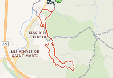
Tocht Stappen van 5,2 km beschikbaar op Occitanië, Pyrénées-Orientales, Le Boulou. Deze tocht wordt voorgesteld door nandaf.

Beschrijving

Boucle en partant du casino du Boulou.
On passe par la Chapelle st Phillipe.
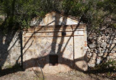
Après une bonne montée on arrive sur les ruines du mas d'en Conte, retour par la piste.

Hoogteprofiel

Foto's

Plaatsbepaling

Land:
France
Regio :
Occitanië
Departement/Provincie :
Pyrénées-Orientales
Gemeente :
Le Boulou
Locatie:
Unknown
Vertrek:(Dec)
Vertrek:(UTM)
486156 ; 4706578 (31T) N.

Opmerkingen

Gelieve in te loggen om een commentaar of een beoordeling achter te laten


Wandeltochten in de omgeving

Tocht Stappen Les Cluses - LES CLUSES 66 - Photo
Stappen
jeff66

Stappen

Gemakkelijk
(9)
Les Cluses, Occitanië, Pyrénées-Orientales, France
9,4 km | 12,8 km-effort
1h 50min
Ja
Tocht Stappen Saint-Jean-Pla-de-Corts - 66 ST-JEAN-PLA-DE-CORTS, promenade autour du Tech, jusqu'au BOULOU  - Photo
Stappen
jeff66

Stappen

Gemakkelijk
(1)
Saint-Jean-Pla-de-Corts, Occitanië, Pyrénées-Orientales, France
7,9 km | 8,8 km-effort
1h 18min
Ja
Tocht Stappen Maureillas-las-Illas - CERET 66 - les hauts de CERET - ballade en bas Vallespir - dolmen de la Siureda torre Bel Ull  - Photo
Stappen
jeff66

Stappen

Medium
(1)
Maureillas-las-Illas, Occitanië, Pyrénées-Orientales, France
6,5 km | 9,9 km-effort
1h 24min
Ja
Tocht Stappen Montesquieu-des-Albères - MONTESQUIEU-DES-ALBERES 66 - Les Agouillous - les chemins de l'eau dans les Albères - Photo
Stappen
jeff66

Stappen

Medium
(1)
Montesquieu-des-Albères, Occitanië, Pyrénées-Orientales, France
12,7 km | 13,9 km-effort
2h 16min
Ja
Tocht Stappen Le Boulou - LES THERMES DU BOULOU - 66 - Albera viva - PUIG de l'Estella - Photo
Stappen
jeff66

Stappen

Medium
(2)
Le Boulou, Occitanië, Pyrénées-Orientales, France
7,3 km | 11,4 km-effort
1h 32min
Ja
Tocht Stappen Les Cluses - LES CLUSES 66 - LE PERTHUS -  - Photo
Stappen
jeff66

Stappen

Medium
(2)
Les Cluses, Occitanië, Pyrénées-Orientales, France
14,4 km | 20 km-effort
2h 57min
Ja
Tocht Stappen Montesquieu-des-Albères - Montesquieu des Albères - Photo
Stappen
nandaf

Stappen

Medium
(1)
Montesquieu-des-Albères, Occitanië, Pyrénées-Orientales, France
7,4 km | 10,9 km-effort
2h 27min
Ja
Tocht Stappen Maureillas-las-Illas - RIUNOGUES PORTELL PANISSAR - Photo
Stappen
MarcOBRECHT

Stappen

Medium
(1)
Maureillas-las-Illas, Occitanië, Pyrénées-Orientales, France
18 km | 26 km-effort
4h 35min
Ja
Tocht Stappen Saint-Jean-Pla-de-Corts - st jean St fereol - Photo
Stappen
66Gribouille83

Stappen

Moeilijk
Saint-Jean-Pla-de-Corts, Occitanië, Pyrénées-Orientales, France
13,5 km | 17,6 km-effort
6h 44min
Ja


Sluiten
Mijn abonnementen